Identity area
Reference code
Title
Date(s)
- 1988 (Creation)
Level of description
Item
Extent and medium
1
Context area
Name of creator
Biographical history
Repository
Archival history
Immediate source of acquisition or transfer
Content and structure area
Scope and content
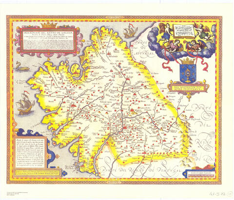
Mapa general del antiguo Reino de Galicia. Edición facsímil publicada por el Instituto Geográfico Nacional en 1988, basada en el mapa aparecido en la edición en español del “Theatrum Orbis Terrarum” de Abraham Ortelius (1603). Incluye decoración cartográfica (cartelas, escudo del reino, galeones), relieve por perfiles de montañas, red hidrográfica principal y toponimia en castellano. Representa también el límite con Portugal.
Appraisal, destruction and scheduling
Accruals
System of arrangement
Conditions of access and use area
Conditions governing access
Conditions governing reproduction
Language of material
- Spanish
Script of material
Language and script notes
Physical characteristics and technical requirements
Escala aproximada 1:875.000 (8 leguas españolas = 5,8 cm). Dimensiones 38 x 47 cm. Mapa a color. Meridiano origen: isla de Hierro (Islas Canarias). Signatura: 41-I-22.
Finding aids
Allied materials area
Existence and location of originals
Existence and location of copies
Related units of description
Notes area
Alternative identifier(s)
Access points
Subject access points
Place access points
Name access points
Genre access points
Description control area
Description identifier
Institution identifier
Rules and/or conventions used
Status
Level of detail
Dates of creation revision deletion
Language(s)
Script(s)
Sources
Archivist's note
Publicado por primera vez en 1603 en el “Theatrum Orbis Terrarum”. Edición facsímil del IGN (Madrid, 1988). Comprende el antiguo reino de Galicia.
Digital object metadata
Filename
T0023602.jpg
Latitude
Longitude
Media type
Image
Mime-type
image/jpeg