Identity area
Reference code
ES 2026.XDPDB.ACF 2026-02-23/197-2026-02-23/197
Title
Golfo de México. Cartas náuticas. 1885
Date(s)
- 1885 (Creation)
Level of description
Item
Extent and medium
1
Context area
Name of creator
Biographical history
Repository
Archival history
Immediate source of acquisition or transfer
Content and structure area
Scope and content
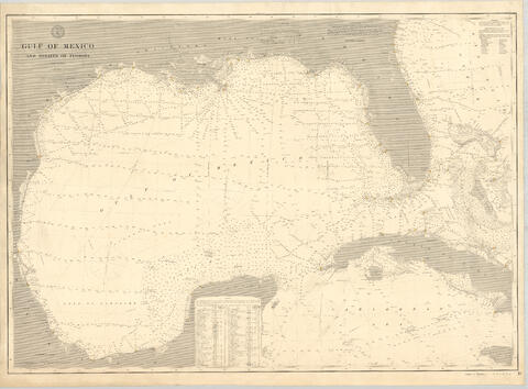
Carta náutica del Golfo de México y del estrecho de Florida publicada en 1885 por el Coast and Geodetic Survey (Estados Unidos). Incluye escala gráfica en millas náuticas y una leyenda sobre tiempo y visibilidad náutica de faros. Está orientada a la navegación marítima del área representada.
Appraisal, destruction and scheduling
Accruals
System of arrangement
Conditions of access and use area
Conditions governing access
Conditions governing reproduction
Language of material
- English
Script of material
Language and script notes
Physical characteristics and technical requirements
Escala 1:2.100.000. 1 carta náutica montada sobre tela, 79 x 108 cm. Incluye escala gráfica en millas náuticas. Signatura: 22-M-9.
Finding aids
Allied materials area
Existence and location of originals
Existence and location of copies
Related units of description
Notes area
Alternative identifier(s)
Access points
Subject access points
Place access points
Name access points
Genre access points
Description control area
Description identifier
Institution identifier
Rules and/or conventions used
Status
Level of detail
Dates of creation revision deletion
Language(s)
Script(s)
Sources
Digital object metadata
Filename
T0031480.jpg
Latitude
Longitude
Media type
Image
Mime-type
image/jpeg
Filesize
25.7 MiB
Uploaded
February 23, 2026 1:16 AM