Identity area
Reference code
Title
Date(s)
- 1608 (Creation)
Level of description
Item
Extent and medium
1
Context area
Name of creator
Biographical history
Name of creator
Biographical history
Repository
Archival history
Immediate source of acquisition or transfer
Content and structure area
Scope and content
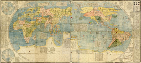
Elaborado en 1608 por el misionero jesuita Matteo Ricci y el estudioso chino Li Zhizao, este es el primer mapa mundial en chino que incorpora los descubrimientos geográficos europeos del siglo XVI. Presenta el mundo en una proyección ovalada, con América, África, Europa y Asia claramente delineados. Incluye textos explicativos sobre cada región, así como ilustraciones de animales y barcos. Fue un hito en el intercambio cultural entre China y Occidente, y se conserva en el Museo de Nankín.
Appraisal, destruction and scheduling
Accruals
System of arrangement
Conditions of access and use area
Conditions governing access
Conditions governing reproduction
Language of material
- Chinese
Script of material
Language and script notes
Physical characteristics and technical requirements
Soporte: Papel xilográfico, coloreado a mano. Dimensiones: 168 x 380 cm (aprox., seis paneles). Técnica: Impresión xilográfica con color añadido. Estado de conservación: Bueno, con restauración parcial. Ubicación actual: Museo de Nankín, China.
Finding aids
Allied materials area
Existence and location of originals
Existence and location of copies
Related units of description
Notes area
Alternative identifier(s)
Access points
Subject access points
Name access points
Genre access points
Description control area
Description identifier
Institution identifier
Rules and/or conventions used
Status
Level of detail
Dates of creation revision deletion
Language(s)
Script(s)
Sources
Digital object metadata
Filename
Kunyu_WanguoQuantu____.jpg
Latitude
Longitude
Media type
Image
Mime-type
image/jpeg