Identity area
Reference code
ES UDC.2025.XED.G1 2025-11-03/147-2025-11-03/144
Title
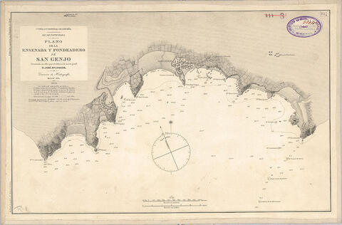
Plano de la ensenada y fondeadero de San Genjo
Date(s)
- 1882 (Creation)
Level of description
Item
Extent and medium
1
Context area
Name of creator
Biographical history
Name of creator
Biographical history
Name of creator
Biographical history
Repository
Archival history
Immediate source of acquisition or transfer
Content and structure area
Scope and content
Escala gráfica en metros y millas. Constan coordenadas de la Pta. de San Genjo. Longitud del meridiano de
San Fernando. Indicación gráfica del Norte magnético. Grabado en cobre. Representación de masas de cultivo
Appraisal, destruction and scheduling
Accruals
System of arrangement
Conditions of access and use area
Conditions governing access
Conditions governing reproduction
Language of material
- Spanish
Script of material
Language and script notes
Physical characteristics and technical requirements
Escala: Escala 1:13.300.
Descripción física: 1 carta náutica: montada sobre tela: 30 x 47 cm
Finding aids
Allied materials area
Existence and location of originals
Archivador 1
Existence and location of copies
Related units of description
Notes area
Alternative identifier(s)
Access points
Subject access points
Place access points
Name access points
Genre access points
Description control area
Description identifier
Institution identifier
Rules and/or conventions used
Status
Level of detail
Dates of creation revision deletion
Language(s)
Script(s)
Sources
Digital object metadata
Filename
09.jpg
Latitude
Longitude
Media type
Image
Mime-type
image/jpeg
Filesize
100.6 KiB
Uploaded
November 17, 2025 3:40 AM