Identity area
Reference code
ES 2026-02-18/166 2026-02-18/158-2026-02-18/166-2026-02-23/189
Title
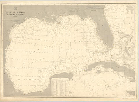
Golfo de Mexico
Date(s)
- 1885 - ? (Creation)
Level of description
Item
Extent and medium
1
Context area
Name of creator
Biographical history
Repository
Archival history
Immediate source of acquisition or transfer
Content and structure area
Scope and content
Appraisal, destruction and scheduling
Accruals
System of arrangement
Conditions of access and use area
Conditions governing access
Con escala gráfica millas náuticas. Leyenda indicando tiempo y visibilidad náutica de faros.
Conditions governing reproduction
Language of material
- English
Script of material
Language and script notes
Physical characteristics and technical requirements
Escala: Escala 1:2.100.000
Coordenadas: (W 99°44'02" - W 75°24'24" / N 32°6'08" - N 17°45'25") Descripción física: 1 carta náutica: montada sobre tela: 79x108 cm
Finding aids
Allied materials area
Existence and location of originals
Existence and location of copies
Related units of description
Notes area
Alternative identifier(s)
Access points
Subject access points
Place access points
Name access points
- Coast and Geodetic Survey, United States (Subject)
Genre access points
Description control area
Description identifier
Institution identifier
Rules and/or conventions used
Status
Level of detail
Dates of creation revision deletion
Language(s)
- English
Script(s)
Sources
Digital object metadata
Latitude
Longitude
Media type
Image
Mime-type
image/jpeg
Filesize
209.7 KiB
Uploaded
February 23, 2026 12:52 AM