Ardal dynodi
Cod cyfeirnod
ES UDC.2025. XED.G3 2025-12-26/145-2025-12-26/151
Teitl
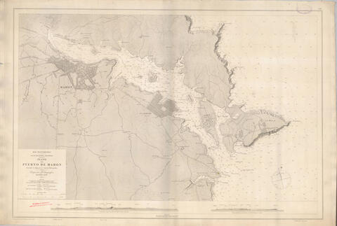
Plano del puerto de Mahón
Dyddiad(au)
- 1906 - ? (Creadigaeth)
Lefel y disgrifiad
Eitem
Maint a chyfrwng
Ardal cyd-destun
Enw'r crëwr
Hanes bywgraffyddol
Enw'r crëwr
Hanes bywgraffyddol
Lleoliad
Hanes archifol
Ffynhonnell
Ardal cynnwys a strwythur
Natur a chynnwys
Carta náutica del puerto de Mahón levantada en 1894 por la Comisión Hidrográfica y publicada en 1906. Grabado en cobre con escala gráfica en millas y metros, coordenadas del Faro del Puerto según el meridiano de San Fernando, indicación del norte magnético e incluye 2 vistas de la costa.
Gwerthuso, dinistrio ac amserlennu
Croniadau
System o drefniant
Ardal amodau mynediad a defnydd
Amodau rheoli mynediad
Amodau rheoli atgynhyrchu
Iaith y deunydd
Sgript o ddeunydd
Nodiadau iaith a sgript
Cyflwr ac anghenion technegol
Escala 1:8.000. Dimensiones: 64 x 96 cm. 1 carta náutica ilustrada. Grabado en cobre. Incluye escala gráfica en millas y metros, coordenadas del Faro del Puerto (longitud del meridiano de San Fernando) e indicación gráfica del norte magnético.
Cymhorthion chwilio
Ardal deunyddiau perthynol
Bodolaeth a lleoliad y gwreiddiol
Bodolaeth a lleoliad copïau
Archivador 2
Unedau o ddisgrifiad cysylltiedig
Ardal nodiadau
Dynodwr(dynodwyr) eraill
Pwyntiau mynediad
Pwyntiau mynediad pwnc
Pwyntiau mynediad lleoedd
Pwyntiau mynediad Enw
Pwyntiau mynediad Genre
Ardal rheolaeth disgrifiad
Dynodwr disgrifiad
Dynodwr sefydliad
Rheolau a/neu confensiynau a ddefnyddiwyd
Statws
Lefel manylder disgrifiad
Dyddiadau creadigaeth adolygiad dilead
Iaith(ieithoedd)
Sgript(iau)
Ffynonellau
Gwrthrych digidol metadata
Enw ffeil
12_141.jpg
Lledred
Hydred
Math o gyfrwng
Delwedd
Mime-type
image/jpeg
Maint ffeil
18.7 KiB
Uwchlwythwyd
2025 Rhagfyr 26 12:42 PM